GPR Utah: Safe and Accurate Concrete Scanning
Sep/21/18
Geographers divide the US into 20 different regions, based on rock formations, mineral resources and geologic hazards. Three of these regions are located in Utah, which makes it a diverse environment in which to build. From limestone and sandstone to granite and sedimentary deposits, these features make identifying underground features challenging. The use of GPR has revolutionized the way surveys are done and construction projects completed.
Georadar is a nondestructive method used to “see” what is below the surface of the ground and building foundations and behind walls and rock. A transmitter sends electromagnetic energy in the range of radio frequencies into the subsurface. This energy reflects back towards the surface when it encounters an object or boundary between different types of materials. The receiving antenna records and displays the signal that is scattered back to the surface, with all of its variations in real-time.
The UHF/VHF frequency range offers a variety of depth and resolution options, based on the area being scanned. For example, ice, which conducts low GPR frequencies readily, can be penetrated for thousands of feet. Dry materials, such as soil, granite, concrete and limestone, resist the radio waves, so penetration is typically limited to less than 50 feet. However, when using higher frequencies, while the distance is limited, the resolution is greatly enhanced. Such technology was used in Egypt to find hidden chambers in King Tut’s Tomb and the Pyramids of Giza.
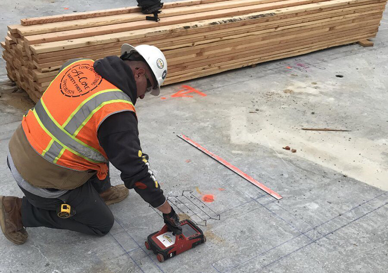
Data Collection
The transmitter and receiver, also known as sending and receiving antennae, are typically used near the ground and close to each other. Traditionally a two-person crew ran georadar equipment. One moved the antenna pair along its assigned trajectory and the other operated the recorder.
Technological advancements have resulted in today’s convenient handheld devices and units that incorporate the controls and antenna into one system that can be pushed like a lawnmower. All these instruments require precise calibration based on the application and target being surveyed. Careful evaluation of the site conditions and objectives are critical to preparing actionable results.
Target Revelations
GPR antennae record thousands of sending and receiving signals every second. Operators are trained to read the blips and dips detected caused by the elemental interactions indicating different types of soil and obstacles. Distances from the surface can be measured as well as the size of the target.
Applications
There are many reasons to look below the surface. Initially, GPR was developed to help the military detect landmines and other unexploded ordnance. Technology refinements have increased sensitivity to also be able to locate bunkers, tunnels and weapons caches. As mentioned above, scanning equipment has helped archeologists find voids indicating previously hidden chambers in ancient Egyptian structures. There are many more applications:
- Earth scientists analyze groundwater and bedrock.
- Law enforcement looks for pertinent case evidence.
- Engineers must routinely detect buried electrical lines.
- Concrete and utility workers locate conduits, rebar and other obstacles.
Concrete Analysis
Concrete is one of the most scanned surfaces today. New construction and renovation projects often call for cutting existing concrete. Any mistake can make the project soar over budget, making the cost of cutting, drilling or coring prohibitively high. Cutting without sufficient info carries multiple potential risks:
- Striking rebar
- Cutting electrical cables
- Damaging communication conduits
- Severing post tension cables
These risks are inherently dangerous for the technicians and may damage or destroy the equipment in use. GPR enables scans on the surface providing engineers critical data about the concrete, such as the spacing and depth of the slab.
Cost Factors
Several factors affect the cost of a project involving concrete analysis:
- Location and objective
- Type of structure
- Quantity of reinforcement in the scanned area
- Required use of lift or scaffolding
The structural mapping process determines the position and depth of targets embedded within a concrete structure. Targets may include obstacles such as rebar and conduits as well as voids or fractures. The goal is to identify and measure the exact target locations.
Injury Prevention
Protecting architectural integrity is crucial to maintaining the safety of a structure. Accurate identification of targets ensures the concrete cutters and drillers steer away from dangerous situations. For example, post-tension cables that are inadvertently severed may break through the concrete’s surface, injuring anyone in the vicinity, from concrete workers to bystanders. Cutting through wires can result in life-threatening injuries as a result of electrical shock.
Benefits of Georadar Technology
GPR offers multiple advantages when it comes to concrete analysis:
- It does not require breaking ground or disturbing surface materials, reducing dust and debris.
- There are no site hazards that require closing off the area, as there is with X-Ray imaging.
- Data is received real-time.
- Physical access to the underside of the slab is typically not necessary.
- Metal objects, poly conduits and pipes can be precisely located.
- Multiple layers of rebar, mesh and post-tension cables, can be viewed.
- Deteriorating areas of the substructure can be identified, reducing risk and preventing injury to workers.
- Slab thickness can be measured.
- Identification of voids and cracks is possible, depending on the radio frequency being used.
Stay on Schedule
Construction projects can be filled with unexpected delays, from finding previously unknown sinkholes to pinpointing the location of electrical lines that do not show up on existing documents. A ballooning budget often accompanies such delays. Ground penetrating radar can identify potential problems before they sabotage the job. Instead of expending more time and money to correcting the issues, the project can continue to move forward.
Ground Penetrating Radar vs. X-Ray Scanning
Being able to avoid potential issues and precisely target the concrete-covered areas for cutting or drilling is critical to finishing the project on time and within budget. Unlike X-ray scanning, GPR has real-time inspection capabilities. This enables saw-cutting and core drilling in a timely manner.
The wide range of antenna frequencies allows technicians to tune the equipment based on the terrain, materials, depth and size of the area that must be scanned. This flexibility allows for a balance between resolution and penetration depth, providing an estimation of the structure’s thickness.
In large projects, such as building bridges, enlarging airport facilities and renovating commercial buildings, GPR concrete scanning can be an invaluable way to accurately determine project costs and schedules. Time and resources can be saved by identifying obstacles and targets before construction even begins.
Sources:
https://historytogo.utah.gov/utah_chapters/the_land/geologyofutah.html
https://en.wikipedia.org/wiki/Ground-penetrating_radar
https://news.nationalgeographic.com/2018/02/king-tut-tomb-hidden-chamber-scan-egypt/
https://archive.epa.gov/esd/archive-geophysics/web/html/ground-penetrating_radar.html
https://www.edoxx.com/single-post/2017/05/22/How-Does-GPR-Scanning-Work
http://www.usradar.com/ground-penetrating-radar-applications/military-humanitarian/
https://www.gp-radar.com/concrete.html
https://www.geophysical.com/wp-content/uploads/2017/10/GSSI-Concrete-Handbook.pdf
http://www.undergroundsurveying.com/technology/concrete-imaging-technology
https://www.a-core.com/services/gpr-concrete-scanning/